![]()
The Continental Divide Route, Part 2
by Jeff Rome
“I only went out for a walk and finally concluded to stay out till
sundown, for going out, I found, was really going in.”
~John Muir
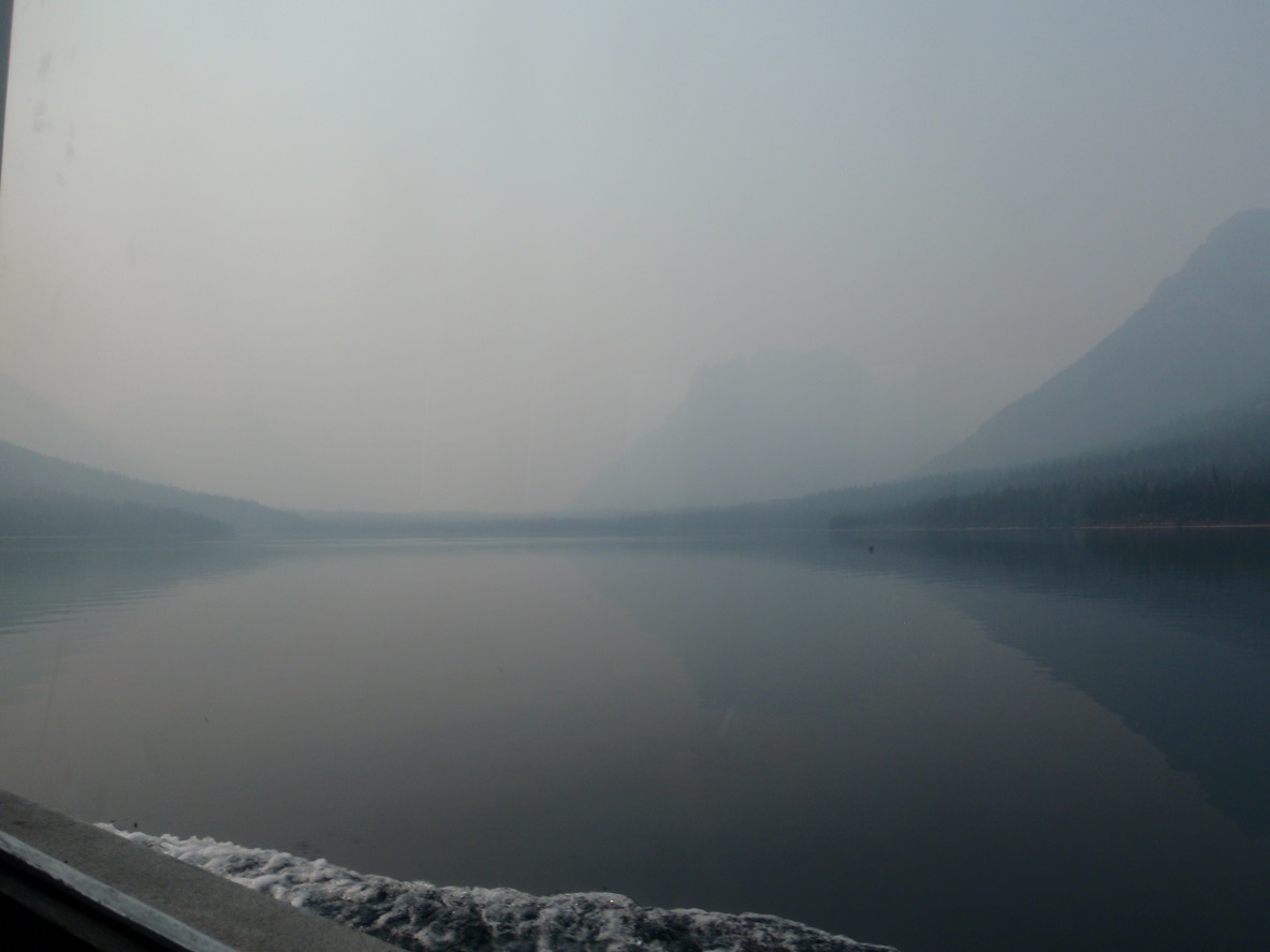
The day dawned forever. Smoke had been creating a sepia toned world in the Rockies, and the difference between near and far is hue–the less color, the further away. I had a window seat on The International, a boat that crosses the Canadian-U.S. border eight times a day during the summer months, and looked out into the grey of the water and the grey of the air. It was 10:30 but still felt dawn, though I’d already been up for five hours.
 |
Waterton Lake, smoky and still
|
Nearly napping, I suddenly awoke when the crew announced that hiking beyond the ranger station requires going through customs. I’d left my passport, ID, cash, everything behind—just like the air, my mind had been unclear that morning. I talked to border control, stayed honest, and then once they told me, unsympathetically, “I’m sorry, I can’t let you through,” I knew I had to be dishonest. I made like I was going to hike all the way back to Waterton, only having bought a one way ticket, and began furtively scouting the hillside for a break in the cliffs as I began the trek.
Who would really believe someone would hike 10 miles back to their car just to get a passport? I began to suspect that border control knew exactly what I was about to do, but I went through with the actions anyway, ready to be honest about my dishonesty when caught. The boat only stayed ashore for 25 minutes, and I imagined my best chance of eluding capture (I felt like a fugitive!) was to be beyond the customs station by the time the boat left. For about 15 minutes I hurriedly hopped over logs, pushed branches out of the way, orienteered through the smoke and the brush, and came upon a trail heading up to the Goat Haunt overlook.
I’d made it, but remained paranoid. I took the trail down to the Waterton Valley junction, ready to dive off into the bushes and hide, figuring the junctions are the most likely place to be caught. Then, for the next hour, my concern was the patrol cabin just pass the Stoney Indian Pass Junction. Fastpacking was really fast for that hour, running some ten or eleven minute miles over flat ground, hoping that by getting there faster whoever was at the patrol cabin would be less likely to expect me. I passed a group of day hikers who had heard me talking to border control, and they were glad to see I’d made it, but this didn’t allow my paranoia to ease up. Does border control ever go undercover? Might a casual day hiker suddenly break out the handcuffs and a taser on me?
Running seemed to be the only thing to alleviate the discomfort of having just done something illegal, and every switchback found me looking down at the switchback below, concerned. The two agents at customs were both stocky and carrying a lot of gear, but I imagined backcountry rangers to be in cahoots with border control, and likely more fit. The pressure stayed on until I left trail, just west of Fifty Mountain Camp, still paranoid but okay with getting arrested, eventually, as long as I could finish the route.
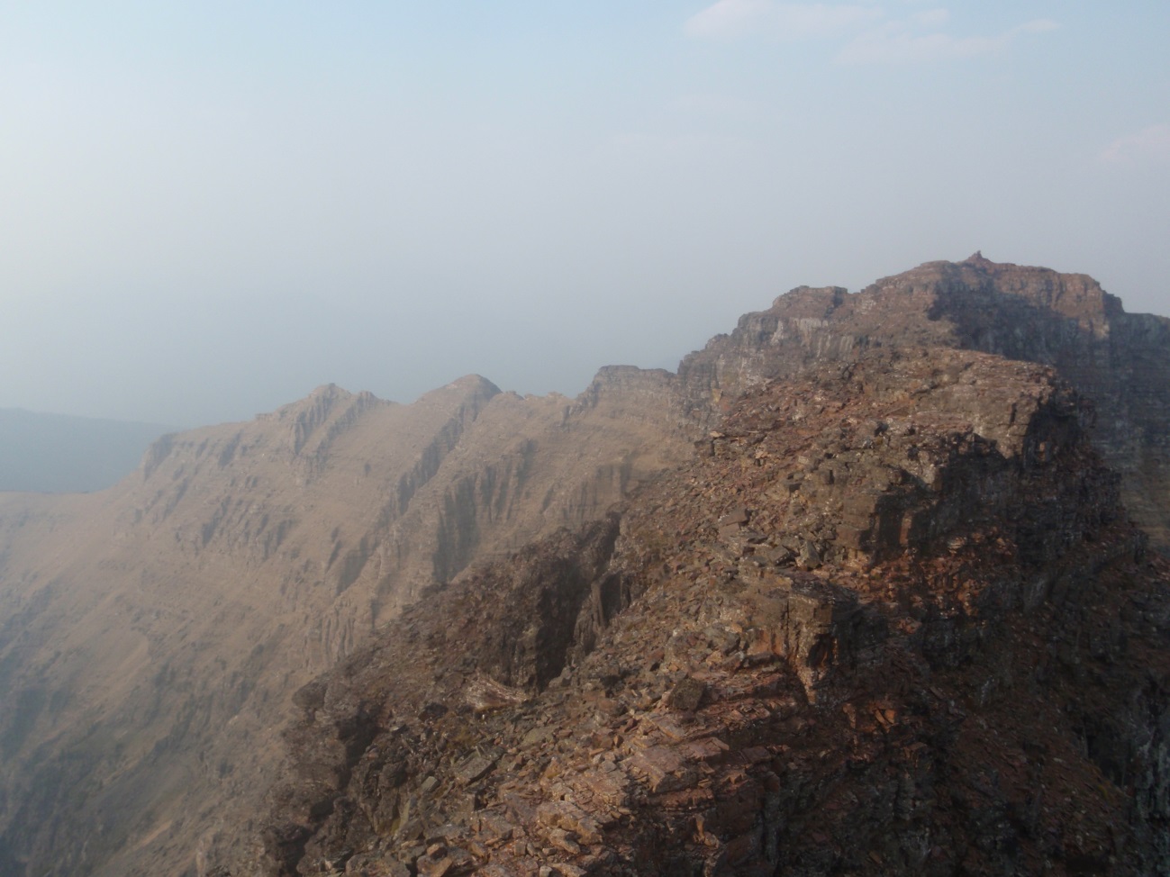
The cross country section from Fifty Mountain Camp to the east end of Trapper Peak is the most nondescript section of the route, and has the lowest point on the divide (5700’) since the start at Marias Pass. After gaining the summit of West Flattop Mountain it really is flat at the top, in all directions. With the smoke still thick, I was losing visibility of the mountains behind me and hadn’t yet seen the mountains ahead, so strolled on through the smoke taking compass readings. For a short while, my world was nothing but grey air, grey burned trees and golden brown grass.
 |
| The least distinct section of the Divide in Glacier Park (which earns it a kind of distinction) |
I spent the night at Gyrfalcon Lake, stopping early at 7:30 since the next water seemed hours away. I lounged, had dinner, pulled out the final map of my pack (map 6) for the next morning, and studied the route. Much of this route has been gleaned from descriptions in Edwards’ book, A Climber’s Guide to Glacier National Park. It’s not always reliable and often vague, sometimes only saying so much as “walk from here to there” when the inbetween is a mile and a half of picking lines through trees, crossing streams, and attempting to stay at the same elevation. It’s like playing connect-the-dots in the mountains, where straight lines don’t exist, but it has more information about routes in the park than any other source.
 |
| Gyrfalcon Lake (I at first thought this was Gyrofalcon Lake, and imagined gyros made out of bird meat) |
 |
| Two miles of ridgetop walking at dawn |
 |
| Miles and miles of traversing on scree slopes |
Once back in the high country, traversing between mountains with more majestic names, visibility was never more than two mountains ahead, and the sky was not big. I skirted the flanks of perhaps the only two mountains I know of that have neither Mt. or Peak in their name (The Sentinel, The Guardhouse), and followed an intermittent goat trail around the western half of Thunderbird Peak. The periods of travelling without a goat trail, above steep rocky cliffs on loose scree, never became something I felt at ease on.
I hit Brown Pass at 2:00 and, after summiting the wrong mountain, made my way over to Mt. Custer and wrapped around the south end of it on another goat trail to find the final few miles of ridgeline into Canada. The day was getting late, especially after having thrown in an extra summit, and my only concern was making it to somewhere with water for the night, which didn’t seem to be anywhere without a large cliff in the way.
 |
| The last difficult mile of ridgeline (the apparent cliff in the middle of the ridge had me very worried) |
 |
| Chasing light into Canada (Forum Peak in photo center) |
 |
| End of the route, Forum Peak summit—Mt. Custer is the humped peak in the background |
This trip began and ended with a chase, trying to avoid a night up on the ridge, thirsty and hungry. I summited Forum Peak shortly after 8, and followed the ridgeline down into the trees, where a border clearing paved the way for a steep and brushy trail (Forum Peak’s northern ridgeline lies on the Alberta-British Columbia border). At a low point on the ridgeline, I started following a faint trail which I presumed to be the Akamina Pass trail, but I was wrong. After a mile of bushwacking, I found myself, in the dark, ashore at Cameron Lake. It was 9:45 and all the hikers had left, so this was home for the night.
I sat on the dock and filled up on water (no manmade water sources about), but had to pick my spot carefully to avoid small fish falling into the suction of water filling. I didn’t have much of a dinner—several handfuls of granola—because sleep seemed the greater need. I felt lazy enough that curling up in a row boat seemed tempting, but instead slept out in the open just yards away from a trail. The stars were visible, and I could hear all the sounds that don’t make it up into the alpine—owls hooting, crickets, the gentle lap of waves falling apart on sand, frogs voicing their strange existence—and felt at peace.
The next morning I started walking, again, down Cameron Lake Road. It felt odd to continue hiking after I’d completed the CDR, and it took an hour and a half, with the sparse outbound traffic during the 7-9 AM hours, until a park ranger stopped for me. Maybe it was just this ranger, or maybe it’s Canada, but he didn’t seem like he was on the hunt for a ticket to give. Even when I told him where I’d camped last night (illegally), he didn’t seem to make note of it. He was able to answer a few questions I had about the descent from Forum Peak, recommended places in town to eat, told me a bit about the history of the area, and seemed like the kind of old guy I’d want to be when I grow up.
So it’s done for the year. This being a multiyear project, the next step will be to get a better idea of how viable a one-push go at this route will be. The key will be getting to the 20+ miles of trail by dark, and working cross country across the broad, flatscape of West Flattop Mt. into sunrise. I imagine starting at midnight and ending near midnight, two days out on the Divide, with a full moon and warm weather. But of course that won’t happen.
There is very little information on the web about any given section of this route, let alone the route as a whole, but I was able to find
this. It provides a good overview of the route, which, used in conjunction with Edwards’
Climber’s Guide, should point CDR aspirants in the right direction. The Missoula Public Library has a mapping program that came in great use for the route (the 100 foot contour intervals on the National Geographic Map aren’t great for cross country purposes), and allows printing on waterproof paper for $3 a sheet. For descriptions of the route, I transcribed sections of Edwards’ book onto race bibs (also waterproof) and kept both map and description readily accessible in my pocket. I saw no bears on this route, and the only off trail humans I saw were in Floral Park. At no point did I need spikes or an ice axe, though this could change with a more snowy year, and everything was 4th class or easier (some of it with significant exposure). The only road along the route is at Logan Pass, and the only option for resupply is at Logan Pass and Granite Park. There are several bailing points, though these become less frequent and involve more travel in the northern half of the route.
There is little else I can compare this route to, except to say that it’s uniquely Montanan. It has the soul of a mountain goat, the heart of a grizzly, and the curiosity of a marmot. It will leave you drained but at the same time fill you with a sense of being. There is a floating feeling that comes from traversing on and near such a long ridgeline. I close my eyes and I’m flying over the route. Whenever I’m not preoccupied and awake, my mind wanders to somewhere along the CDR, taking in the feeling, the surroundings, the knowing that I’ve been there and so far, far along that ridge. Whatever the opposite of PTSD is, I have that.
Now, readers, it’s up to you to find your dream route. The best possible line, the most interesting way to run to work, the best five mile loop in the woods, the run or hike or scramble that will leave you someone else, whether the route be big or small, a daily ritual or a once in a lifetime trip. This is it for me, the CDR, and now that I know where I need to go it’s taken me somewhere I’ve never expected.
 runwildmissoula.org >>