 runwildmissoula.org >>
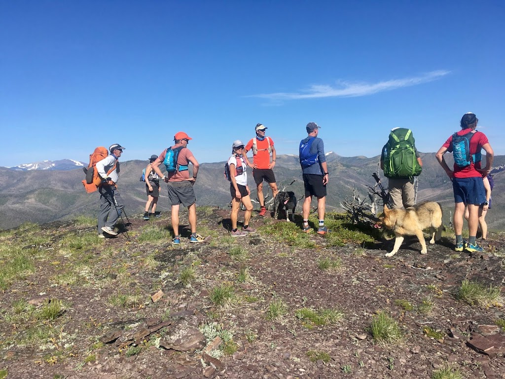
A Guest View of Tim’s Summer(s) on the CDT: Part 7 – The Bob
By Steve Brown

The Bob Marshall Wilderness is an irresistible force. So when I learned that my good friends Tim Mosbacher and Ken Ellis planned to traverse it last July as part of their Montana CDT quest, I checked their dates, cleared my calendar and not-so-subtly asked if I could be the third wheel for a few days. They politely agreed. Here’s my glimpse into what Tim and Ken do all day when they’re out there, why their trek is so remarkable, and what we saw. So pull out your Bob maps and follow along.
Originally I planned to join them at Benchmark around July 4th and accompany them north into Glacier. But Glacier’s east side remained closed, so it wasn’t possible to follow the CDT past Marias Pass. Then some horribly inclement weather the week before blew Tim and Ken off the trail just north of Helena. They did some quick revisions and decided I could join them from Rogers Pass to Marias Pass, then they’d come back later and pick up the gap. This led to an unanticipated bonus to camp in Lincoln July 3rd, the night before we started. Let’s just say that Lincoln’s Independence Day crowd is slightly different from Missoula’s and leave it at that.
We left Lincoln early Saturday morning and proceeded to Rogers Pass accompanied by seven trail-running escorts. Rogers Pass crosses the Continental Divide not far from the spot of the lowest recorded temperature ever in the lower 48, but July 4 was clear and cool. Perfect hiking weather.
Like many, I’ve driven over Rogers Pass dozens of times and sort of vaguely wondered where the stairs on the north side of the highway lead. I now know they lead to an amazing ridgetop trail that follows the crest of the divide north for miles, up many small mountains and down to lower obscure passes – Cadotte Pass, Lewis & Clark Pass and numerous unnamed others. The crew from Missoula accompanied us for the first 10 miles, and the banter was typically light hearted. Despite it being a perfect July holiday, we saw hardly anyone else — one couple, and one southbound CDT through-hiker named Sloppy Joe.
Our escorts turned back after about three hours. It was sort of sad to see them go. The terrain quickly became even more rugged, most of it well over 7000 feet in elevation, treeless and dry. To our left, the southwest slope dropped precipitously into Alice Creek and other Blackfoot River tributaries. To our right, north-facing cliffs fell into trailless tributary drainages of the Dearborn. The divide itself was a carpet of wildflowers, with plenty signs of grizzlies digging for roots, but no actual sightings. We intercepted Missoula trail runner Tom Allard coming from somewhere up north, still with miles to go to his Rogers Pass destination. Late in the afternoon, short on water, we dropped into a buggy cirque below Caribou Peak. From there, we climbed back up to another gorgeous bowl high above Bighorn Lake. The wind started to blow super hard. We made a rocky descent to another pass, and I fell and broke one of my poles. I needed the poles to support my tent, and we hadn’t even camped a night yet, with seven nights ahead. (Duct tape and a tent stake split fixed it nicely.) But finally we found a relatively calm spot with live water and fire-scarred trees and quit for the first day.
The morning of the second day I quickly realized Tim and Ken follow a carefully-honed routine. Sometime after 5 a.m. the sky lightens and business starts. No hot breakfast. No coffee. Just pack up, choke down some kind of bar and be off before 6. Coffee (at least for me and Ken – Tim just dreamed of Mountain Dew) comes sometime late morning. Pretty much each of the next six days repeated this rhythm. Ken and Tim are very efficient, and it works.
Our Sunday route climbed back up to the divide briefly with long views toward Scapegoat Mountain, bathed in golden morning light. Ken spotted elk on a high ridge peering down at us. We soon dropped more than 2000 feet down a beautiful trail to the Dearborn River. The Dearborn was swift and we carefully forded it. It was the first of many fords. We turned west and followed the trail upstream. By lunch we made it to Welcome Creek. We’d run through this area in 2011 and remembered a piped spring. The pipe still flowed cold, fresh and clean nine years later.
The afternoon took us up and over Straight Creek Pass. The pass is pretty, with rushing water on both sides but rocky and hot. Late in the afternoon we reached a fork in the trail and a decision point. Left was the “official” CDT trail as marked on the map. It required a deep ford of Straight Creek, then an ascent of Elbow Pass followed by a descent into the South Fork of the Sun drainage leading north to Benchmark. Straight continued down Straight Creek. It’s a CDT “alternate” that led straight into Benchmark–no ford or pass required. The choice seemed simple to me, but I still felt like a guest. Thankfully Tim and Ken have clear minds, so straight it was. It turns out that there may be an “official” CDT route, but there are many alternates along the way, some large and some small, but none of which subtract from the legitimacy of the whole. (Except maybe the Anaconda Cutoff — I really don’t get that one.) I was happy because I’d been over the Elbow Pass route twice, but never down Straight Creek, and it allowed me to color in another trail on my master Bob map. We marched a few more miles and camped at a vaguely flat spot below swaying burned snags, hoping they didn’t blow over and squash us at night.
Monday, we woke unsquashed and started the day with an easy five-mile stroll into Benchmark. Not surprisingly, we quickly passed several spots that would have been much more pleasant camps, but it didn’t matter. We exited the wilderness briefly and walked a road for a mile or so from one trailhead to another. Benchmark has been the start or finish to several RATBOBs, so it seemed a bit like coming home. All that was missing was a cooler full of cold drinks and the circle of friends.
From Benchmark we followed the popular and familiar trail leading to the Chinese Wall. It’s a beautiful trail up the West Fork of the South Fork of the Sun. The trail is mostly open and the view of the winding river and the red mountains is spectacular. Plenty of water (and repeated wet feet, despite the occasional bridge), a great lunch spot at the Indian Meadows backcountry cabin, and a late afternoon rugged climb up to the alpine zone where we found a gorgeous camp site surrounded by glacier lilies. Another 25-mile day and it really felt like we were deep in the Bob because we were.
Tuesday started with the Chinese Wall. The Chinese Wall is beyond superlatives. We’ve run to other walls in the Bob – the one below Scapegoat and the North Wall, both of which are incredibly dramatic. But the Chinese Wall is in a different league. The 1000-foot shear vertical and miles-long horizontal scale of it are impossible to adequately describe. Its remoteness only adds to the mystique. Some say the eight miles from Salt Mountain to Larch Hill are the finest alpine segment in Montana, and it’s hard to argue. If it were in Glacier on a July day, it would be overrun with tourists, but on this July day we had it all to ourselves.
The north end of the Wall trail got snowy and muddy and stayed that way for a long while. After passing My Lake, we began dropping in elevation down to Spotted Bear Pass. There we crossed back to the west side of the divide, and it greeted us with rain and blowdown. It’s a long ten miles down the Spotted Bear River in a big U-shaped west side valley. The trees are tall and the river fords deep. We’d see no more bridges this trip. We camped near the Pentagon Cabin, having finished the day with a cold ford of Pentagon Creek. Ken built the only fire of the week, and life seemed pretty civilized until it started to rain again.
Wednesday, day 5, was my favorite because it took us to terrain I’d never seen, and it felt like we’d reached the wild heart of the Bob. We started the day with dry shoes and socks, but it didn’t last long. After about two miles we again forded swift, icy cold Pentagon Creek and started a squishy ascent of Switchback Pass. Switchback Pass earns its name. Ken started tallying the switchbacks but soon lost count when he quickly ran out of fingers. But the more we climbed, the more scenic it became. We looked back south into the long Spotted Bear valley we’d descended the previous day. West were the distant Swans. Pentagon Mountain loomed over us to the north. Near the top it got cold and windy, but it still was nice to be up high again.
Switchback Pass sits on the side of a mountain that forms a triple divide between tributaries of the Middle and South Forks of the Flathead, and the North Fork of the Sun – all big rivers that drain significant portions of the Bob. Our digital maps also told us Switchback Pass might have the first cell signal in five days. Ken and I hunkered under a tree while Tim investigated. No luck. So we crossed the pass and moved north on a high shelf, still full of snow. We soon passed Dean Lake, framed by fields of glacier lilies and the hulking mountains behind it. We proceeded north, paralleling the east side of the remote Trilobite Range. This stretch was truly amazing, almost as pretty as the Wall section, but so much wilder.
We ate lunch by a cold stream, then descended another switchbacky trail into the Clack Creek valley. The trail was beautiful, fairly newly reconstructed and passing very close to an enormous noisy waterfall. Once we reached the valley floor, it was easy hiking for several miles until we reached the Middle Fork of the Flathead, which would be our biggest river crossing yet.
Some southbound hikers told us it was possible to cross the Middle Fork on fallen logs. That was sort of true. We found the logs, but they still had most of their thick branches, so the crossing required some old man gymnastics. As generally was the case, Ken pretty much skipped across. Tim also crossed elegantly. I nervously struggled not to fall in. The river was braided and required a second crossing, but it was much easier. The second crossing took us right to Gooseberry, where we joined the well-trodden Big River Trail. Gooseberry also felt super remote, and it was because it’s 20 miles or more in any direction to any road.
From Gooseberry we followed the Middle Fork upstream to its source at the confluence of Strawberry Creek and Bowl Creek. There we rejoined the “official” CDT again, having last left it at Spotted Bear Pass. We turned north into the wide Strawberry Creek valley, following it upstream in and out of burned areas.
Somewhere in here the chicken-fried steak talk started. I’ve never actually ordered a chicken-fried steak and couldn’t quite tell from Ken and Tim’s descriptions whether to be intrigued or mortified. I think it was a little of both, but the banter about this delicacy continued periodically for three days. Wednesday finished by a Strawberry Creek tributary out of the burn, but full of mosquitos.
Thursday, day 6, was another day of wet feet. We forded the creek right at our campsite and each time our shoes dried out, we’d ford another. The trail climbed to Badger Pass and the east side of the divide. The Strawberry Creek drainage burned in 2015 and 2017 and still is quite charred. The pass isn’t super dramatic, but the trail stays up high, crossing back and forth across the divide three times in three miles. The last crossing was at Muskrat Pass in an extensive bog. Even though we were dropping into the east side again, the trail was a watery mess for the first few miles. Finally it climbed up the north slope, giving long views of the ridge that makes up the divide. Somewhere along here we passed two through-hikers heading south. The male half of the couple carried a very large pistol. They complained about the mosquitos and blowdown and didn’t seem to be from Montana. But they were well armed.
We finished Thursday near the Badger guard cabin. We now were out of the Bob and in the Badger-Two Medicine, which is a wild triangle of national forest surrounded by the Bob, the Blackfeet Reservation, and Glacier Park. It was so gorgeous traipsing up and through the meadows in the upper tributaries of Birch Creek and Badger Creek. At the Badger cabin we met a family of six from Florida on their way to tackle the whole CDT in one summer. Pretty impressive family adventure. We camped in a meadow near the cabin, feeling pretty content with just one partial day to go.
Friday, day 7, dawned gunmetal gray. Sometime overnight it started raining again, and this rain didn’t stop. We borrowed the Badger cabin covered porch to pack up and began the last day’s slog. It was less than 20 miles to Marias Pass, and the cold rain didn’t dampen the smell of the barn and the prospect of chicken-fried steak. Our route took us up and over a low pass that divides the headwaters of North Badger Creek from those of the South Fork of the Two Medicine. The rain made the trail muddy and slippery.
After a few miles we reached another decision fork. The official CDT climbs out of the river valley and up onto the flank of Elkcalf Mountain, traversing it for several miles. Several southbound hikers we’d met warned us of bad blowdown, and we were leery. The alternate was a trail along the South Fork of the Two Medicine, which supposedly included several bypass trails to avoid deep fords. We opted for the Two Medicine Trail.
I’m still not sure we made the right decision here, although we did live through it. My maps weren’t detailed enough to show the number of times we’d have to ford the river. The high water bypass trails were pure fiction and blocked by extensive blowdown. So we were committed to fording and re-fording. Each ford was downstream from the previous, and the river was accumulating water from tributaries and rain. Some fords were in fast water with slippery rocks. When the trail wasn’t in the river, it was in the willows along the river. The mud on the trail had very fresh grizzly tracks, and I was pretty convinced we’d run into one any time. But I really wasn’t that worried because I hiked between Tim and Ken and figured the bear would find one of them more attractive.
We never did see the actual bear that made the tracks. We forded the river at least nine times that morning. It was cold, but we made them all successfully. After the last ford we turned west for the final ascent to Marias Pass. We arrived at the pass sometime around noon. In a way it was sort of anticlimactic to be back in civilization, sitting under the big obelisk trying to get a cell signal to summon a ride out. Tim did finally get ahold of his wife Becky and she promised to be there first thing the next morning.
We spent the rest of the day in the Forest Service campground at the top of the pass waiting for the Summit Steakhouse to open. Our neighbors were two wide-eyed kids from Brooklyn, out to see America on their stimulus checks. Noisy trains rumbled through several times each hour. Finally the restaurant opened, and even though it was pretty fancy and I’m sure we looked and smelled horrible, the food was great (despite the lack of the fabled chicken-fried steak). The next morning Becky picked us up and drove us back to Lincoln so Ken and Tim could continue their adventure.
Ken and Tim are awesome hiking companions. They are savvy, indefatigable and always in good humor. The stretch we covered together is magical and I feel pretty fortunate they let me be part of it. It also left me for a new appreciation of how much dedication it really takes to through-hike the CDT, especially the Montana section.


